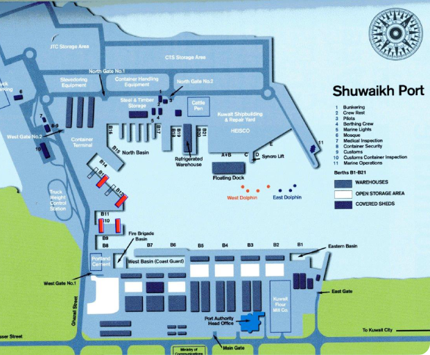
Shuwaikh port is the main commercial port in the State of Kuwait. It is located to the immediate North and East of Kuwait City. Shuwaikh navigation channel is about 8 Kms long.The port has 21 berths including 2 container berths.
Vessels sailing to and from the port pass through a Navigation Channel dredged inside Kuwait Bay. The channel is about eight kms long and its depth is maintained at 8.5 M at minimum water tide level. The port can receive vessels of 7.5 M draft at Zero tide and vessels of upto 9.5 M draft at High tide.
PORT LOCATION
Latitude : 29 Deg 21.30 N
Longitude : 47 Deg 55.54 E
Admiralty Chart : 1214
Admiralty Pilot : 63
Time Zone : GMT + (Plus) 3 Hrs
Port Security Level : 1 (One)

24 Hours Pilotage available except during shift timing 0600 – 0900 approx every day. Contact Harbour Control on Channel 16 / 11
- Lat 29 Deg 25.0n, Long 47 Deg 58.7E subject to Port permission
- Approx 18 M / Muddy
- Channel Low Point minimum draft - 7.0 M
- Add 7.0 M to figure quoted from Tide Table as High or Low Water
- Result will be Maximum Available Water
- Water Density 1.025
- Maximum ARRIVAL DRAFT should not Exceed 9.50 M Due to Draft limitations in channel
Shuwaikh Port control to be notified on VHF channel 16, about 4 hours prior vessel and also when passing the following :
- Ahmadi Racon (35 N Miles approx From Pilot station)
- Position Lat 28 Deg 21.5N, Long 48 Deg 53.0E
- Abeam Ras Al Ard
- Position Lat 29 Deg 21.5N, Long 48 Deg 08.5E
- 3 Miles to Pilot station
- Pilot Boarding about 1 Mile from Entrance (Ras Ajuzah) : Lat 29 Deg 25.6N, Long 47 Deg 59.6E
Details of Berth
| BERTH NOS | MAX L.O.A IN M | A/S DRAFT IN M | EXTIMATED COMMODITY WISE |
|---|---|---|---|
|
|
|
|

